PCGEOFIM
The simulation programme for geofiltration and geomigration PCGEOFIM calculates groundwater flow and the transport of soluble substances in unconsolidated rock. Due to the complexity of the flow and solute transport processes, the extent of temporally variable parameters and other input variables, an analytical model approach is no longer possible.
- Recording and forecasting groundwater dynamics and groundwater quality
- Support for the remediation of groundwater damage
- Complex consideration of the water balance in connection with BWHM ArcEGMO
- Potential impacts of climate change on groundwater supply
- Designation of drinking water supplies
- Designation of drinking water protection zones
- Especially Montane Hydrology
- Monitoring of mining water management measures
- Temporal change of terrain topography and land use in the model
- Support for rehabilitation mining
- Mapping the interaction of flowing and standing waters
- Calculation of seepage lines in the slope area
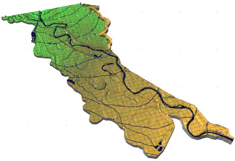
PCGEOFIM is therefore a numerical simulation programme and uses the finite volume method to solve the underlying differential equations. This approach enables very true-to-balance results, i.e. inflows and outflows in the entire model are accurately recorded and reported in a way that is comprehensible to the user. In this way, it is possible, for example, to calculate the resurgence of a residual opencast mine and to make a forecast of the expected final water level. The numerical approach requires a decomposition of the model area (discretisation) into a grid. Each grid element is also referred to as a volume element due to the mathematical solution procedure. Since the procedure does not place any special requirements on the shape of the volume elements, a flexible discretisation of the area to be modelled is also possible. This means that boundary conditions such as rivers, lakes or drainage wells can be taken into account very precisely in the model.
Features of PCGEOFIM
The programme system consists of two components and has numerous features to be able to describe the water balance as comprehensively as possible.
Components of the PCGEOFIM programme system
PCGEOFIM is a programme package consisting of the simulator Geofim and the graphical user interface PCGeofim. The simulator represents the actual simulation core and carries out the calculations. With the help of the user interface PCGeofim the model construction as well as the result evaluation (pre- and postprocessing) are carried out. The user is supported in modelling by numerous tools and import interfaces. The output of hydroisohypses plans is done in true-to-scale map representation and allows the user a problem-oriented model evaluation. A description of further features and possibilities can be found here.
Graphical user interface tools
Of the total of over 30 tools, only a few are listed and described below, which support the user in the model evaluation.
Isohypse
The tool Isohypse offers, among other things, the overwriting-free output of the measured values as a measured value map, the evaluation of the measured values in dialogue with the user, the specification of outer and inner boundary contours in dialogue and, after triangulation, the representation of the measured values in the form of isohypses and isosurfaces. Great importance is attached to the interpolation of the measured values, which is true to the supporting point. During the construction of the isolines, standing water and flowing water can be optionally included.
Geoisol
The Geoisol tool generates isolines and isosurfaces from the stored mirror heights and concentrations of the Geofim calculation. The water levels in the standing waters are taken into account in the construction of the isolines. In addition, measuring points, streamlines and migration points can be transferred to the graphic. The output can be done on monitor, plotter or printer. Export to scale is possible in various formats (e.g. HP-GL/2 and ESRI-Shape-File).
Geogang
The tool is used to visualise the results from GEOFIM calculations in the form of time functions (hydrographs): Output to screen, plotter, printer and export to other programmes (e.g. as HP-GL/2 file, PostScript file or AutoCAD file).

Geopara
Element-related graphical representation of the input parameters, including boundary conditions and topography. The output can be in different formats, analogous to the Geoisol tool, whereby GIS-supported model editing is possible when exporting to the ESRI shape file format.
PCGEOFIM has been specially developed for the requirements of mining and post-mining water management. A special feature of the Geofim simulation tool is that it can fully model the cavities that have been created and are being created in the mining industry and thus take them into account in the balance sheet. However, classical problems of groundwater dynamics can also be dealt with.
Model geometry
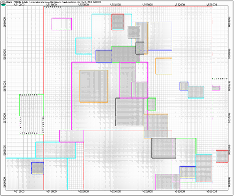
With PCGEOFIM, the flow and transport processes can be modelled and simulated in 1D, 2D and 3D. The discretisation for the 2-dimensional space is basically done in a regular quadrilateral grid, so that cuboid volumes are created in the 3-dimensional space. In order to offer the user the possibility of creating a more flexible mesh geometry, the so-called magnifying glass structure was developed and implemented. These magnifying glasses can refine the basic grid in both horizontal and vertical directions. Thus, a more precise indication or recording of local conditions (e.g. geological conditions, location of boundary conditions) is possible. The arrangement of the magnifiers is not determined by a hierarchy, so that both embedded and overlapping areas can be represented.
In the PCGEOFIM programme, boundary conditions are implemented in many different ways so that facts can be optimally represented in the model. Some boundary conditions are listed here as examples:
- 1st, 2nd type as well as 3rd type (also with restrictions)
- Time-constant or time-variable definable
- Well, possibility to define well ageing
- Definition of vertical filter well
- Opencast mine boundary condition for setting drainage targets
- Standing and flowing waters with coupling to the aquifer
- Flooding to map infiltration
Features
Geofim
- Flexible mapping of time-dependent "parameters" in the model. Parameter here stands for
- Thickness of a finite volume (removal/addition of an element possible)
- kf-value
- Disturbances in x-, y- as well as z-direction (e.g. for mapping seal walls)
- Groundwater recharge
- Initial water level
- Effective porosity
- Storage coefficient
- Isothermal
- Concentration
- Direct and indirect coupling of standing and flowing waters with each other to map watercourse systems, overflows, water elevations, etc. with restrictions
- Calculation of mass transfer by means of flux limiter (up to 15 migrants) or random walk method
- Calculation of path lines via freely definable walking points
- Automatic parameter identification and optimisation according to the Gauss-Newton method for hydraulic and transport-relevant parameters
- Well optimisation for calculating the optimum number of production wells and production rates when specifying several possible protection targets
- Scale-appropriate, map-based output of hydroisohypsis plans
- Presentation of the contents is layer-oriented
- Output of hydrographs for
- all boundary conditions
- Predefined groupings for standing and flowing waters, wells as well as balances
- custom points
- Calculation and output of hydrodifferential plans
- Additional output of path lines and flow arrows
- Optional display of wells and measured values
- Representation of vertical-plane sections as a result of seepage line calculations
- Gradient-oriented labelling of isolines
- Design options through user-defined specification of labels and legends
- Export of model results as HP-GL/2 plot files, Esri shape file, Microstation dgn file and Surfer grid file
- Graphical comparison of model variants using hydrographs and isohypse diagrams
- Clipping polygons and surfaces
- Area calculation
- Tool for rectification with control points
System requirements
The minimum requirements in the table below are kept moderate, as PCGEOFIM does not require any special hardware or software. No additional runtime environment is required. For larger projects, significantly more powerful hardware is recommended, as indicated in the middle column of the table. Today's processors have the ability to clock themselves up. This is particularly noticeable when only one processor core is utilised by an application. They also have multi-level, very fast intermediate memories (caches), which can mitigate the rather slow access to the main memory. If several simulations are to be run simultaneously, a multi-channel main memory connection is highly recommended to reduce the impairment in execution speed.
The hardware requirements can also be roughly classified according to the number of finite volumes of the model. For small models up to approx. 50,000 finite volumes, the minimum requirements according to the left column are usually sufficient. For model sizes up to 350,000 finite volumes and / or parallel execution of a few variant calculations, the values in the middle column are recommended. For large-scale models and especially for parallel execution of numerous model variants, hardware equipment according to the column "Optimal" is recommended.
PCGEOFIM was tested under the following operating systems: Windows 8.1 (32+64 bit), Windows 10 (32+64 bit), Server 2012 R2 and Server 2016.
| Minimum requirement | Recommended | Optimal |
| Intel Core or comparable AMD processor (CPU must have SSE3 units) | Intel Core i7 of the 9th generation or AMD Ryzen 7 3rd generation processor | Intel Xeon or AMD Ryzen Threadripper processor of the respective current generation |
| 4 GB RAM | 16 GB RAM (two-channel configuration) | 32 GB RAM (four-channel configuration or higher) |
| 10 GB free hard disk space | 500 GB free hard disk space (SSD) | 1000 GB free hard disk space (SSD) |
| Windows 8.1 (32 bit) | Windows 10 (64 bit) | Windows 10 (64 bit) |
Tips for working with dBase files
For editing the input files (dBase format) it is recommended to use e.g.
- dBase
- DOS version only runs under 32-bit operating system
- for 64-bit operating systems, DOSBox is an alternative
- Using a virtual machine with 32-bit Windows installed
- Microsoft Access
- up to and including version 2010
- Access 2016 (with update from May 2017) and higher
- Tables are included as a link
- SQL queries can be executed and saved
- Column format cannot be changed due to the linkage
- Microsoft Excel
- up to version 2003 with native dBase export
- Output via plug-in possible from version 2007
- Column formatting is changed by Excel when the first column is empty
- GIS software
- Esri ArcGIS, ArcView etc.
- QGIS, Grass (Open Source)
The table below lists the parts of the documentation and briefly explains their contents. Below you will find a zip file containing the entire documentation again.
| Name | Content |
| GeofimDB.pdf | Geofim database |
| Isohypse.pdf | Evaluation, processing and visualisation of measured values |
| Geoisol.pdf | Construction of isolines from calculation results |
| Geosaver.pdf | Output of tables from calculation results |
| Geogang.pdf | Construction of hydrographs from calculation results |
| Geopara.pdf | Graphical as well as tabular representation of the Geofim parameter files |
| PCGView.pdf | Output of graphic representations on screen; export to plotter, printer and GIS |
| PCGEdit.pdf | Notes on the use of dBase in the PCGEOFIM programme system |
| PCGTools.pdf | Collection of useful auxiliary routines |
| Cut.pdf | Creation of a vertical plane section with PCGEOFIM |
| Theory.pdf | Physical and mathematical basics |
| PCGReader.pdf | Output of graphic representations on screen; export to plotter, printer and GIS (freeware) |
Here you will find all parts of the documentation packed in one file (additionally rohrgerinne.xls as well as trapezgerinne.xls).
Here you will find the file templates for the database folder for single-digit magnifier designations.
Here you will find the file templates for the database folder in the new structure.
Licensed PCGEOFIM users include
- Lausitz Energie Bergbau AG, Cottbus
- Lausitzer und Mitteldeutsche Bergbauverwaltungsgesellschaft mbH
- Mitteldeutsche Braunkohlengesellschaft mbH, Zeitz
- Institute for Water and Soil Dr. Uhlmann, Dresden
- G.U.B. Ingenieur AG, Freiberg
- HPC AG, Merseburg
- CDM Smith Consult GmbH
- UBV Umweltbüro GmbH Vogtland
- Dresden University of Technology, Institute for Waste Management and Contaminated Sites